running in the E/W direction, and the N/S direction spearheaded at both ends with large, numerous yards in Lima, Ohio and Dayton, Ohio. This intersection has a single one-sided Y track connecting them as seen here via Google maps: (http://maps.google.com/maps?hl=en&ll=40 ... 6&t=k&z=17)
Now, so far, alot of the downloadable routes (freeware and payware) focus on the moutainous west or the inner-city NEC, and even the mountainous Horse Shoe Curve (which I bought and I love it!
 ). I've been looking for routes characteristic to the midwest landscapes and industries in the modern era.
Are therre any routes based in any of these states in the modern U.S. ? I think I could get in to em a little more as I see these types of trains and freight everyday. I see how they work, the cargo, and the daily switching of loaded/empty cars from industries along the lines. ( I used to work at a plastic pellet factory for Japanese automobiles. Raw material in the form of pellets would come in center-flow hopper cars, and I would stage the cars with the engineer on the tracks in which the material would be drawn from...very exciting!
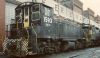
 ) I know the types of cargo, the roadnames, etc. (CSX, Conrail...Coke, autoracks, frame rails, container cars and intermodals to name a few.)
 I have the assets, the knowledge and the capability to build a TS'12 route for all four directions. I can travel to "scope out landscapes, map track and label industries in and around my area. I can take pictures of the scenery and video tape all kinds of freight lines and cargo going through my little city. I only live a couple blocks from either direction, and I even have a scanner app for my smart phone that monitors CSX radio frequencies! I know what they're doing!

BUT, the bad thing is, I dont have the skills OR the patients and time to create such a thing and turn it into a playable route for TS'12. Ive tried with MTS for a long time, and there is just so much to put in and create! My goodness, and the route creator skill is phenomenol and so demanding...I hit one or two bumps in the making, I get mad and give up. I literally annoyed forum goers with question after question after question. Soon I realized there was no way I could had the time, nor the disiplined patience and mindset to make it work.
So, if any of you route building guru's want a challenge, and would like to bring the midwest U.S. of A., particularly the four pronged CSX route that runs N/S from Dayton to Lima via Sidney, and the E/W route running from Anderson, Ind. or as far as Indianapolis, Ind. to Marion, Oh. to reality on TS'12, I would be happy to help in any way I can. The Big Four Bridge here is a local railroad icon. Sidney's rail lines have a decent history with multiple lines:
"Sidney has two railroad lines. Both were built independently in the 1850s.
Until the 1960s one could board the Knickerbocker Limited in Sidney and then step down in Grand Central Terminal in New York City. This east-west line was built as the Bellefontaine and Indiana Railroad which ran from Galion, Ohio to Union City on the Ohio-Indiana border. It was built in conjunction with the Indianapolis and Bellefontaine Railroad thus providing a route from Cleveland and the East to Indianapolis, and later St. Louis. In 1864, the two were merged into the "Bee" Line: the Bellefontaine Railway, in 1869, into the first "Big Four": the Cleveland, Columbus, Cincinnati and Indianapolis Railway, and in 1889, into the second "Big Four": the Cleveland, Cincinnati, Chicago and St. Louis Railway. In the early 1920s, this railroad relocated its tracks from downtown Sidney to the south edge of the city over the then new Big Four concrete arch bridge. Early in the twentieth century, it was leased by the New York Central System. Later the Big Four was taken over by the Penn Central, then Conrail, and finally CSX Transportation.
In the 1950s one could board a train in Sidney and step down in Cincinnati or New Orleans. This north-south line was built as the Dayton and Michigan Railroad. In the 1860s it was leased by the Cincinnati, Hamilton and Dayton Railroad. It was taken over by the Baltimore and Ohio Railroad early in the twentieth century. Later the line was taken over by the Chesapeake and Ohio Railroad, then by CSX Transportation." courtesy wikipedia.com
I will be willing to provide photos and scenic information as well as the specific names of local industries (even if it means traveling). In the event this idea comes to reality I will forfeit any credit whatsoever and leave the credit where credit is due...with the route builder themselves. (including if it becomes payware, I will not ask for money!) All I am offering is an idea...a suggestion and a plea for someone to make a route at least within the U.S. Midwest area. If I cannot provide in depth reference to specific scenic and industrial information to the area being modeled, I can provide assistance in track mapping via google maps (or whatever) and provide any coordinates and route info as I find it available. Basically, I want to make a modern U.S. Midwestern route through all the small towns, servicing graineries, small industries, occasionally running to and from larger switching yards. Id like to see the lush farmlands boardering either side of the tracks, with cattle grazing, the farmer waving and the daily small town factory switch that makes the driver have to time himself when he ventures onto the mainline to run the consists past the switch and quickly run them back into the correct spur before a long haul unit train carrying hundreds of automobiles from Detroit barrels through heading to Dayton to be shuffled into seperate directions. I can paint many pictures of this, But man I cant do it!
 If I can just assist a skilled builder with such a route, and sit in my office and run the game and actually drive my train accross the Big Four Bridge just like I've seen seen thousands of times in real life...aaahhh, that would be awesome. I would pay top dollar for such a route...even if I helped make it in some ways! (By the way, NEC route is almost $40 to buy on steam. Man, thats twice as much as I paid for the entire figgin' game WITH the upgrade! Is it worth it??)
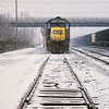


 Good point on starting a route myself. And the route involving my home town of Fort Wayne would be great! Lots of N&W there too. I've run a Rich Garber route on MSTS before...he's pretty good. I'll check those out. Also ill take the advice and begin messing around with route copies.