Welcome to the third in a series of posts on the development of the New York Division-Bergen Line for Train Simulator. If you just got here, and want to catch up on what has happened in the first 5 years view the links below.
Thread 1 from May 2015 to April 2017:
http://railworksamerica.com/forum/viewtopic.php?f=31&t=13875
Thread 2 from April 2017 to September 2019:
http://railworksamerica.com/forum/viewtopic.php?f=31&t=18449
What is the New York Division-Bergen Line
Well, officially we are an accurate representation of Norfolk Southern and MTA/NJ Transit service in Southern New York and Northern New Jersey. Route climbs from Hoboken, NJ, through the Hackensack Meadowlands past the City of Middletown in Orange County, NY. for 74.0 miles of main line running. Full, deep scenery provides an immersive setting that celebrates the rich railroad history of this line. "This route does not disappoint!"
But it is so much more. The modern day presentation is merely an overlay of the rich and deep history that lies beneath. If you look a little deeper, you will find parts of the Eire and Erie-Lackawanna Railroads. Places such as Mahwah, Carlton Hill, Harriman and part of the Old Boonton line are there as they were then. We try to connect history to today to bring the past alive on this route. The scenery is as accurate as we can make it. Streets, Highways, Houses, Buildings and even telephone poles are placed where they are or were to assist in making the virtual as believable as possible.
So, join us on our journey, to go as far as we can, to invoke the rich railroading history of this place.
New York Division-Bergen Line: Episode III, The Erie Rises
New York Division-Bergen Line: Episode III, The Erie Rises
![]() by minerman146 » Sat Sep 14, 2019 3:41 pm
by minerman146 » Sat Sep 14, 2019 3:41 pm
You do not have the required permissions to view the files attached to this post.
Last edited by minerman146 on Wed Oct 30, 2019 8:35 pm, edited 1 time in total.
"In business, I prefer to keep company with honest men, so I ship on the Erie"
-

minerman146 - Posts: 2507
- Joined: Fri Mar 20, 2015 8:15 pm
- Location: Cornwall, New York
Re: New York Division-Bergen Line: Episode III, The Erie Rises
![]() by minerman146 » Sun Sep 15, 2019 1:52 pm
by minerman146 » Sun Sep 15, 2019 1:52 pm
Many thank to Alan from Leeds - we have 10 new subscribers in past 2 days. It must be people from UKTransim checking out the route.
"In business, I prefer to keep company with honest men, so I ship on the Erie"
-
minerman146 - Posts: 2507
- Joined: Fri Mar 20, 2015 8:15 pm
- Location: Cornwall, New York
Re: New York Division-Bergen Line: Episode III, The Erie Rises
![]() by OpenRailer90 » Sun Sep 15, 2019 2:30 pm
by OpenRailer90 » Sun Sep 15, 2019 2:30 pm
Can't wait to see more progress from this route! Hoping to see Port Jervis in the not-so-distant future.
- OpenRailer90
- Posts: 1720
- Joined: Tue Jun 24, 2014 6:34 pm
Re: New York Division-Bergen Line: Episode III, The Erie Rises
![]() by AmericanSteam » Sun Sep 15, 2019 7:17 pm
by AmericanSteam » Sun Sep 15, 2019 7:17 pm
It's Deja Vu all over again.
Apologies to Yogi Berra.
Apologies to Yogi Berra.
Just an old Alaska guy trying to live in an insane world. Degree in life, Masters in common sense.
-

AmericanSteam - Posts: 2958
- Joined: Mon Nov 02, 2015 9:54 am
- Location: Nikiski, Alaska
Re: New York Division-Bergen Line: Episode III, The Erie Rises
![]() by bswitzrw » Mon Sep 16, 2019 9:21 pm
by bswitzrw » Mon Sep 16, 2019 9:21 pm
Truly, an amazing journey!
- bswitzrw
- Posts: 88
- Joined: Tue Jul 16, 2019 4:39 pm
Re: New York Division-Bergen Line: Episode III, The Erie Rises
![]() by buzz456 » Tue Sep 17, 2019 7:20 am
by buzz456 » Tue Sep 17, 2019 7:20 am
Coming to a simulator near you in a short time.
You do not have the required permissions to view the files attached to this post.
Buzz
39 and holding.
"Some people find fault like there's a reward for it."- Zig Ziglar
"If you can dream it you can do it."- Walt Disney

39 and holding.
"Some people find fault like there's a reward for it."- Zig Ziglar
"If you can dream it you can do it."- Walt Disney
-

buzz456 - Site Admin
- Posts: 21392
- Joined: Sun Mar 21, 2010 8:30 am
- Location: SW Florida
Re: New York Division-Bergen Line: Episode III, The Erie Rises
![]() by minerman146 » Tue Sep 17, 2019 9:36 am
by minerman146 » Tue Sep 17, 2019 9:36 am
Buzz, You know I am going to love it. As for the budding and existing Erie and EL fans - the FA1 will get its chance to haul some tonnage across the division, and they will love it too!
"In business, I prefer to keep company with honest men, so I ship on the Erie"
-
minerman146 - Posts: 2507
- Joined: Fri Mar 20, 2015 8:15 pm
- Location: Cornwall, New York
Re: New York Division-Bergen Line: Episode III, The Erie Rises
![]() by minerman146 » Tue Sep 17, 2019 10:04 pm
by minerman146 » Tue Sep 17, 2019 10:04 pm
This post is an observation and a tip on how I handle all the glorious trees on this route. As I am moving West, now about 4 Miles west of the station, the foliage is changing. I see a large increase in the amount pines and the size of clusters or rather small forests of them. As they are becoming more prominent. I take care to present them as accurately as possible. So, lets go to the picture.
As you can see I use the Google Overlay to place everything. In this situation, I need to see what KIND of pine are we looking at from the sky. In the left side of the picture you see a house surrounded by pines. Fortunately there was a street view of the this place and I got a shot from November. From the air the profile of this tree looks the same, so I will operate under the assumption that its the same type of pine. I also spot check other pines that I can can see from the street.
In the last shot, this is my rendering in game. Similar trees! I added some fir for shadow and to increase the density.
The key thing about coniferous trees and evergreens is that they show up really nicely in Winter, particularly with all the denuded deciduous as contrast. I promote this as an all season route. This is another reason the depth of my scenery exceeds 1500 feet on each side of the track.
The final shot is a landscape shot before I put the leafy trees, foliage and grass in. I would call this about 50 percent done in this shot. For me, each section is really a scene that I focus on to capture a the real life location and translate that to the game. I spend time during build sessions viewing the subject area from as many angles as I can.
Its this type of work that makes the route look like it does.
You do not have the required permissions to view the files attached to this post.
"In business, I prefer to keep company with honest men, so I ship on the Erie"
-
minerman146 - Posts: 2507
- Joined: Fri Mar 20, 2015 8:15 pm
- Location: Cornwall, New York
Re: New York Division-Bergen Line: Episode III, The Erie Rises
![]() by minerman146 » Wed Sep 18, 2019 9:00 pm
by minerman146 » Wed Sep 18, 2019 9:00 pm
Its Wednesday again and time for the Wednesday Route Update Post: Shiny New Thread Edition.
Its so nice and roomy here, no beer bottles on the floor (yet) and thanks to our new member logon requirements - no riff-raff.
So lets get down to it and check in on the Friday Route Update status for this week:
[ ] Workplace Accident
[ ] Union Dispute
[ ] No Cerveza, no Trabajo
[X] All of the Above
Hmm. Well, suffice to say we need to kick some tires and light some fires into the weekend and make some progress. The good news is that we have about 4 miles at 50% and greater scenery. I am just not getting the hours in the route anywhere near pace (3 hours per day). But were moving, and when I am in game working its productive. I still got juice - we can do this!
I do have some other news regarding the Super Secret Spy Squirrel Project. I have seen images from the project and it is progressing. Of course, not only can I not show you pictures, I wont even describe this very special project. But you will all enjoy it - I promise. I have some research work for the project that requires some fieldwork which I hope to do this Saturday. I cant tell you where I am going either as that … uh, its privileged!
Anyway, last night's post was good indicator of where we are at with 4 miles in and another 5.5 to the tunnel … not too shabby! And so it goes.
Carry on!
"In business, I prefer to keep company with honest men, so I ship on the Erie"
-
minerman146 - Posts: 2507
- Joined: Fri Mar 20, 2015 8:15 pm
- Location: Cornwall, New York
Re: New York Division-Bergen Line: Episode III, The Erie Rises
![]() by Overshoe » Thu Sep 19, 2019 3:25 pm
by Overshoe » Thu Sep 19, 2019 3:25 pm
I made instant coffee in the microwave and went back in time.
You do not have the required permissions to view the files attached to this post.
-Tom Constantine
Acer Nitro N50-656, Core(TM) i5-14400F, 16 GB RAM, NVIDIA GeForce RTX 3050 /8GB, Win11 64bit up to date. Acer 23" monitor @ 1920x1080 x2
Acer Nitro N50-656, Core(TM) i5-14400F, 16 GB RAM, NVIDIA GeForce RTX 3050 /8GB, Win11 64bit up to date. Acer 23" monitor @ 1920x1080 x2
-

Overshoe - Posts: 574
- Joined: Mon May 26, 2014 4:49 pm
- Location: Bangor, Maine
Re: New York Division-Bergen Line: Episode III, The Erie Rises
![]() by minerman146 » Wed Sep 25, 2019 8:28 pm
by minerman146 » Wed Sep 25, 2019 8:28 pm
And here are again for this week's Wednesday Route Update. Let's kick off with our usual Friday Update probability.
Lets check in with our guest assessment from Private Hudson
[ ] We’re on an express elevator to hell, going down
[ ] I say we take off, nuke the site from orbit. It’s the only way to be sure
[ ] Aye-formative
[X] Game's over man, game's freaking over! What the heck are we gonna do now? What are we gonna do?
Such drama! I should have saved this weeks response for when we find out there will be no Train Simulator 2021, because that IS what I would say!
Motion, progress is all I care about in the project. Work gets me, getting sick gets me and that's it. I still have the passion and the drive. Just this morning, thinking about this post beforehand, I was thinking about the Otisville Tunnel. I have some great shots of it being built, the entrances of course, and some shots the interior of it, with lighting as it was being prepped for a spray on concrete liner. So, I am going to try to model the darn interior of the tunnel. Its interesting too, it has like a 4 or 5 foot high brick lining running a good portion of it and some brick linings. This is the end, why the heck not make it as interesting as possible?
So here is where we are now - just a little further West
Bowser Road is very close to where the Old Mainline and the Graham Diverge, I did model the roadbed, rather the sub roadbed, so you get an idea of where and what it is. The other end, of course is down in Harriman. This would be very cool to recreate in another iteration. We already have bit off just about more than what we can chew already. Speaking of the Tunnel and the Graham, and how we mix up the years, the whole Graham Line was double tracked, except the Moodna. The Otisville Tunnel was as well until the late 50s when they single tracked it to allow for Piggybacks, its also high enough in the center for double stacks.
I have a shot below of the Bowser Road Overpass below. What really just amazes me is how many miles we are West of Suffern now.
For me, this is inspirational. This route is becoming...monumental. The East end of the tunnel is 80 miles to Jersey City. That is a wow. Then I consider all the branches and I think we got quite a bit of railroad to play with here. So, when I get to that tunnel, I can do another 10 and I will drag myself across broken glass to cross the Delaware River.
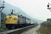
And last up is my glamor shot of my short freight at SF tower. I am loving the new graphic controls. But I love it more when Overshoe takes glamor shots!

Carry On!
Lets check in with our guest assessment from Private Hudson
[ ] We’re on an express elevator to hell, going down
[ ] I say we take off, nuke the site from orbit. It’s the only way to be sure
[ ] Aye-formative
[X] Game's over man, game's freaking over! What the heck are we gonna do now? What are we gonna do?
Such drama!
I should have saved this weeks response for when we find out there will be no Train Simulator 2021, because that IS what I would say!Motion, progress is all I care about in the project. Work gets me, getting sick gets me and that's it. I still have the passion and the drive. Just this morning, thinking about this post beforehand, I was thinking about the Otisville Tunnel. I have some great shots of it being built, the entrances of course, and some shots the interior of it, with lighting as it was being prepped for a spray on concrete liner. So, I am going to try to model the darn interior of the tunnel. Its interesting too, it has like a 4 or 5 foot high brick lining running a good portion of it and some brick linings. This is the end, why the heck not make it as interesting as possible?
So here is where we are now - just a little further West
Bowser Road is very close to where the Old Mainline and the Graham Diverge, I did model the roadbed, rather the sub roadbed, so you get an idea of where and what it is. The other end, of course is down in Harriman. This would be very cool to recreate in another iteration. We already have bit off just about more than what we can chew already. Speaking of the Tunnel and the Graham, and how we mix up the years, the whole Graham Line was double tracked, except the Moodna. The Otisville Tunnel was as well until the late 50s when they single tracked it to allow for Piggybacks, its also high enough in the center for double stacks.
I have a shot below of the Bowser Road Overpass below. What really just amazes me is how many miles we are West of Suffern now.
For me, this is inspirational. This route is becoming...monumental. The East end of the tunnel is 80 miles to Jersey City. That is a wow. Then I consider all the branches and I think we got quite a bit of railroad to play with here. So, when I get to that tunnel, I can do another 10 and I will drag myself across broken glass to cross the Delaware River.
And last up is my glamor shot of my short freight at SF tower. I am loving the new graphic controls. But I love it more when Overshoe takes glamor shots!
Carry On!
You do not have the required permissions to view the files attached to this post.
"In business, I prefer to keep company with honest men, so I ship on the Erie"
-
minerman146 - Posts: 2507
- Joined: Fri Mar 20, 2015 8:15 pm
- Location: Cornwall, New York
Re: New York Division-Bergen Line: Episode III, The Erie Rises
![]() by minerman146 » Mon Sep 30, 2019 7:57 pm
by minerman146 » Mon Sep 30, 2019 7:57 pm
Happy Monday All
You know, I drag myself upstairs every night I can to lay more houses , plant more grass, and put those forest in. I do it day and day out. Why do it? What's the reward?
Someday my friends ... someday.
I have a dream.
You know, I drag myself upstairs every night I can to lay more houses , plant more grass, and put those forest in. I do it day and day out. Why do it? What's the reward?
Someday my friends ... someday.
I have a dream.
You do not have the required permissions to view the files attached to this post.
"In business, I prefer to keep company with honest men, so I ship on the Erie"
-
minerman146 - Posts: 2507
- Joined: Fri Mar 20, 2015 8:15 pm
- Location: Cornwall, New York
Re: New York Division-Bergen Line: Episode III, The Erie Rises
![]() by minerman146 » Wed Oct 02, 2019 7:53 pm
by minerman146 » Wed Oct 02, 2019 7:53 pm
Welcome to this edition of the Wednesday Route Report. (aka: As The Route Turns)
So, lets check that status shall we?
[ X ] We got a long way to go
[ ] Sure thing, lets whip up that update right away.
You got to keep in mind, that I used to run updates when I hit some prominent feature. Typically, this was a station, which we had boatload of when we were in North Jersey. Up here in "The Woods", I can lay 10 miles before we get to something interesting. At this stage, unless I find some big error, I will hold back until Otisville. Now if some of you want the 5 new miles of woods, swamps and bi-level houses, just say the word!
I want to get the Wednesday post out quickly so I can return to the build. Today, I will be discussing some history and a route building issue I happened open this week. Lets go the picture that kicks off the conversation.
We are facing East and looking at what was and still is called Howells Junction. Doesn't look like too much in the shot. That signal in the distance is at MP 76.7, if you can believe that, and it also marks the End/Beginning of the Graham Line. I had laid this track about a month or more ago, and have been working on the scenery to about a mile West of these switch. I terminated, as I usually do, before my next super elevated turn. When I stopped laying track, I thought I looked way to high above the terrain. I always use track maps and match the grades for that special touch of added realism. But I also use this to confirm my elevation. Elevation is a big deal for me. Good scenery depends on it. Usually, I can correspond a flat spot to a topo map, Goggle earth and my eyeball using Google/Bing Street view. What really help are street views from overpasses, so I can see the track from above and get an idea of how deep the cuts are and roughly how high the highway is above the track. Talk a look at the Graham Line track map.
You can see the and at 76.6 and we got an upgrade of .57. I had been following this. After this map, which were both done in 1983 by Conjob, I have to switch to the track grade for the main line, as you see in the next shot. And it notes Howells Junction.
After the junction we continue on at .59. And continue I did. The switch went in, then I did the double track and curve beyond Derby Road and ran my straight out a mile or so. But I was too darn high. A couple days ago, the scenery was catching up to the end of my track, so I thought it was time to put in the next curve and straight- about 2 miles of track. Now I can see for sure I am to high. I take the in game rulers out, get good elevation readings on the imported terrain, and I'm like, 8 meters off where ended the track before, and it looks like about 15 meters at the end of my new track.
What the heck happened? My elevation was solid to Bowser Road. Instead of lifting the terrain to match the track. (Trusting my track maps), I got nervous that this elevation would continue to put me too high at the tunnel. Look at the MainLine Map, from MP69 to Derby road. See it? It says .10. Its a flat spot! And why is it flat? History! I will explain this a little later. What I did was lay another track, using .10 next to my existing track and ran that to Derby Road, per the map. I resumed the .59. The end result was my test track was lining up nicely to the existing terrain. The track was running 8 to 9 meters under where I confirmed the elevation of an over pass. Then I knew my track was lining up to the terrain. So, I spent the last 2 sessions relaying the track. Tonight, for safely, I will lay the track to Otisville Station, just before where it goes single track through the tunnel.
Ok history. I like history and I like the Erie. It is not my life's work to be an Erie RR. historian. But, the nature of my work here leads to study what I see on the route and discern, why it is there. Howell's Junction has become a case in point. Lets go to my home made graphic.
What we notice is that from 1909 to sometime in the 1950's All four points, Old Main West, Old Main East, Graham line West and Graham Line East all converged here at Howell's Junction, what is is flat? Why put all that interlocking on the .59 grade (Possible) or it was that the Old Main going West was at .10.(also possible). As we can see, track maps dont lie, by reducing my .57 grade to .10 per the map and then continuing the official grade, that lined up my track to match the terrain.
In my final shot from my personal collection and never published to the inter-webs, is my 1964 hand drawn map by an Erie Lackawanna Employee who was employed by the signals department.
Just look at all the detail in the drawing. And let me tell you, where I can, I integrate the little details and names I see and put them in the route. I also have a boat load of other information to build my 1974 EL Route. I would love to do it. But if I cant get EL as official DLC and have my pals over at Dovetail to sign off ... Well, it becomes just a labor of love. What do I gotta do to get some darn official recognition ovah hee-yah?
This is such a darn cool route. Tell a friend.
Thats it for this week, oh, and Carry On!
You do not have the required permissions to view the files attached to this post.
Last edited by minerman146 on Wed Oct 02, 2019 10:05 pm, edited 1 time in total.
"In business, I prefer to keep company with honest men, so I ship on the Erie"
-
minerman146 - Posts: 2507
- Joined: Fri Mar 20, 2015 8:15 pm
- Location: Cornwall, New York
Re: New York Division-Bergen Line: Episode III, The Erie Rises
![]() by buzz456 » Wed Oct 02, 2019 8:27 pm
by buzz456 » Wed Oct 02, 2019 8:27 pm
You do not have the required permissions to view the files attached to this post.
Buzz
39 and holding.
"Some people find fault like there's a reward for it."- Zig Ziglar
"If you can dream it you can do it."- Walt Disney
39 and holding.
"Some people find fault like there's a reward for it."- Zig Ziglar
"If you can dream it you can do it."- Walt Disney
-
buzz456 - Site Admin
- Posts: 21392
- Joined: Sun Mar 21, 2010 8:30 am
- Location: SW Florida
Re: New York Division-Bergen Line: Episode III, The Erie Rises
![]() by PennCentral670 » Thu Oct 03, 2019 7:55 am
by PennCentral670 » Thu Oct 03, 2019 7:55 am
Lovely shots! Can't wait to get my hands on those FA-1's! 
-
PennCentral670 - Posts: 152
- Joined: Tue Jun 21, 2016 10:17 am
- Location: Westchester County, New York
Who is online
Users browsing this forum: No registered users and 49 guests