New Route: Bessemer & Lake Erie (collaboration wanted)

Post your FREEWARE 'Works in Progress' here!

New Route: Bessemer & Lake Erie (collaboration wanted)

Unread postby Celidude » Fri Mar 21, 2014 11:58 pm

Well seeing asI finally got ahold of some Bessemer hoppers, the new T-2 repaints and my own SD7 repaint, I figured it's time they had a route to run on and since I have all the research sources at my fingertips (i.e. all three books and the Greenville Museum staff) and a passion for the line I figure it might as well be me to start it. However time isn't really on my side, I have about a month before I have to take a 6-month haitus while I deploy so I'm really hoping I can get a collaboration going on this thing. I can get the trackwork down (or atleast a good chunk) and if I get past that a little terra-forming, but there's no way I'll get to scenery and such. I'll be honest, I'd rather have someone else do the decorating anyway because I'd be such a stickler on myself that I'd never get anywhere, if someone else does it then at least it'd be done.

So what's my plan? Well, I figure I'll try and stick as close to the current track plan as possible and then add the sections that have been pulled up (so older eras can be run, and will leave a realistic tree-absence if I delete the rail for newer scenarios) and finally a good portion of interchange railroads for realism, especially if the B&LE ran on them from time to time. For example the current NS (former CR, former EL) line that runs from Greenville to Wheatland that the B&LE would run ore down to the steel mills. Hopefully I can get the track down with a solid month of work time, I just hope someone here wants to take up the other half of the job.

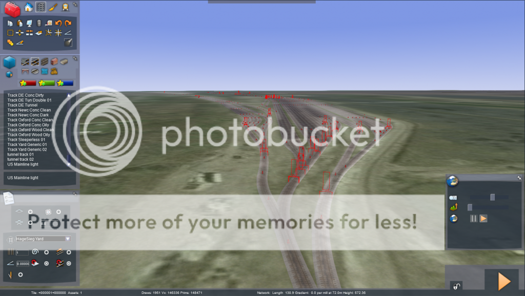
But enough talk, now that the research is done, it's time for action.Today I got started by looking at my rail chart and raising the land to 572, setting the bar at my lowest point: Conneaut Yard on Lake Erie. Why raise the land? So I can just look at the chart, check the next elevation and raise to that heingt, cutting out any extra math. I then traced the rest of the route to the same level so I can't get too far off my path by mistake. Then, tracklaying commenced, and by the end of the day, Conneaut Yard was done, and I have pics to prove it. It's not perfect by any means but it's as close as I could get it.
Image
Image
Image
Image
Celidude
 

Re: New Route: Bessemer & Lake Erie (collaboration wanted)

Unread postby Celidude » Sat Mar 22, 2014 11:12 am

Ok, so I've run into a bit of a snag. I went back in this morning to start laying track out of the yard and the first section is supposed to be a minor incline, however once I put in any gradient settings (literally anything from 0.0001 and up) the track shoots straight up into the air. I've everything I can think of: disable Snap-to Track, disable Snap-to Terrain, enable Easements, enable Follow Route, enable all, enable none, clear the Cache, etc. The only thing I could try now would be the gradient tool but I don't ever have much luck using it, and that kind of defeats the entire purpose of my charts...

Anyone know what I'm doing wrong?
Celidude
 

Re: New Route: Bessemer & Lake Erie (collaboration wanted)

Unread postby GRE3839 » Sat Mar 22, 2014 5:07 pm

PM me and i will help you put the incline in *!!wink!!* !*salute*! *!greengrin!* **!!2cents!!** Private message would work and i can explain it to you via skype and i will give you the details in the PM on how to contact me there
GRE3839
 
Posts: 22
Joined: Sun Mar 16, 2014 11:22 am
Location: Spring Lake, Michigan

Re: New Route: Bessemer & Lake Erie (collaboration wanted)

Unread postby Celidude » Sat Mar 22, 2014 9:39 pm

I'd definitely appreciate it, unfortunately I don't have Skype capabilities (i.e. mic/cam) on my desktop, but any info is always useful if you can get it into some sort of visual aid !!*ok*!! . I'm starting to think it's more of a bug in the system because I tried it on an older route I built just by inputting gradients and it's doing the same thing. It may be caused by my Railworks folder being just shy of 95GB and a lot of the add-ons aren't quite installed entirely right but who knows.

I also think I'm going to try and take a few steps back and see if I can't use Redem to import the terrain and the rebuild, I just have to figure out how to place the route markers it requires to generate the coordinates. If someone can link me to an explaination on the process I'd appreciate it, YouTube and the search bar haven't quite panned out.

One last question and I'm pretty sure the answer is 'no', but is there a way to get RW to use feet instead of meters?
Celidude
 

Re: New Route: Bessemer & Lake Erie (collaboration wanted)

Unread postby glenn68 » Sun Mar 23, 2014 4:01 pm

Could this be a dream come true?

Glenn
User avatar
glenn68
 
Posts: 967
Joined: Mon Aug 09, 2010 1:21 pm

Re: New Route: Bessemer & Lake Erie (collaboration wanted)

Unread postby Celidude » Sun Mar 23, 2014 7:00 pm

glenn68 wrote:Could this be a dream come true?


Provided I can get the terrain generated and the track layer cooperates with me, it will be. If you'd like to be a part of the beta-test/tweaking/population process let me know !!*ok*!!
Celidude
 

Re: New Route: Bessemer & Lake Erie (collaboration wanted)

Unread postby GRE3839 » Fri Mar 28, 2014 11:40 am

i can help with the beta testing and i can show you a few pointers as well Via skype and pm me and i can give you the details on how to get ahold of me
GRE3839
 
Posts: 22
Joined: Sun Mar 16, 2014 11:22 am
Location: Spring Lake, Michigan

Re: New Route: Bessemer & Lake Erie (collaboration wanted)

Unread postby jesseg199 » Fri Mar 28, 2014 1:37 pm

i can do more repaints for cars and engines umm could probably do some scenery
User avatar
jesseg199
 
Posts: 76
Joined: Sun Jan 27, 2013 12:42 am

Re: New Route: Bessemer & Lake Erie (collaboration wanted)

Unread postby glenn68 » Sat Mar 29, 2014 10:22 am

what era are you going to model after? Modern?
The older days of the B&LE was cool, did a lot of reading up on them from books I have. Would be great to see some older SD-M lash up but there is no short hood SD9 available.
If you are going to go with a earlier era with you include the Western Allegheny?
I would think that the harbor would be the hardest to model since the Ore Hullett machines are not available in RW.
If you need a BETA tester count me in.

Sorry about the choppy messaging, had surgery a few days ago and not feeling good at all.

Glenn
User avatar
glenn68
 
Posts: 967
Joined: Mon Aug 09, 2010 1:21 pm

Re: New Route: Bessemer & Lake Erie (collaboration wanted)

Unread postby Celidude » Sat Mar 29, 2014 7:34 pm

glenn68 wrote:what era are you going to model after? Modern?
The older days of the B&LE was cool, did a lot of reading up on them from books I have. Would be great to see some older SD-M lash up but there is no short hood SD9 available.
If you are going to go with a earlier era with you include the Western Allegheny?
I would think that the harbor would be the hardest to model since the Ore Hullett machines are not available in RW.
If you need a BETA tester count me in.

Sorry about the choppy messaging, had surgery a few days ago and not feeling good at all.

Glenn


Ideally I'd like to include any rail that the B&LE ran on through thier entirety, including lines that no longer exist, and then from that template create separate era routes by deleting lines that were removed to fit the dates. For example the branch to Conneaut Lake Park (aka Exposition Park) that existed until the '50s-60s but was removed, so they won't appear in a route dated after the '60s.
True, the Hullets aren't available but that's where a little "creative engineering" might produce something similar until someone makes them. The same can be said about the rotary dumper on the BLE/CSX(CR) interchange in Conneaut.

Hopefully I can get this terrain stuff figured out, I'm working with BNSFsubdivision on how to do it, but I'm trying to use the most accurate terrain scans (1/9 arc seconds) where his tutorials and the older tools are for lower quality formats. If anyone's used the 1/9 formats on a route, I could really use the info on how to convert it for RW.
Celidude
 

Re: New Route: Bessemer & Lake Erie (collaboration wanted)

Unread postby GRE3839 » Mon Mar 31, 2014 9:50 am

take a look at my route called the Grand Rapids Eastern to see how i put the grades in and i have been working on the route since November of 2013. I am the only one working on my route so go check it out to see how my route first started and i am more than happy to show you how to build a route from the very beginning if you need help making it
GRE3839
 
Posts: 22
Joined: Sun Mar 16, 2014 11:22 am
Location: Spring Lake, Michigan

Re: New Route: Bessemer & Lake Erie (collaboration wanted)

Unread postby Celidude » Tue Apr 08, 2014 7:20 am

Well guys, I hate to say it but I'm at a complete loss. I tried to uninstall/reinstall RW (after backing it up elsewhere of course) to see if it would alleviate the issue I'm having with inclines but the track still shoots straight up into the air when I try to put one in. I also noticed that it doesn't tell me a percentage grade anymore, but a 1m over X distance (ex. 1m over 500m or 1:500) when adjusting the track or running the route. I'm not sure when this changed but I noticed it when this issue first started and it's probably part of my problem.

On the terrain note, I still haven't figured out how to download the ArcGIS program to run the 1/9 arc second maps (most accurate version, +/-3m), so I'm gonna try using a lower quality, maybe the 1/6 (+/-10m?) and see if it gets me somewhere. I still have a a couple weeks before I ship out and I'm gonna try to build a new computer while I'm away so I can work on this. For as much as I've fallen behind so far, I'm not gonna leave this sit 6 more months with no progress. If someone knows how to generate the terrain I'll gladly forward you the required files. Honestly if it weren't for the trackage problem I wouldn't need the terrain generated, I'd just lay the track and move on.
Celidude


Return to Freeware WIP

Who is online

Users browsing this forum: No registered users and 1 guest

cron