Crooked & Weedy

Post your FREEWARE 'Works in Progress' here!

Re: Crooked & Weedy

Unread postby arizonachris » Tue Feb 22, 2011 10:53 am

RedWhistle wrote: I have never packaged anything yet for RW, so in terms of getting it ready for that, along with the appropriate credits and such, will be a process to learn about yet for me.

Red


Looking better and better, Red! Whetting my appetite for yet another great route. !!*ok*!!

As far as packing up stuff and giving credit where it's due, if you look at some of the "readme" files for some of the other routes offered here (Tori's route is a great example) you may get an idea of how to give credit and link to additional downloads/ payware that needs to be acquired. Packaging, you're on your own (I'm just a driver, for now anyways !**duh*!! )
Ryzen 7 2700K, Asus Prime X570P, 32Gb DDR4, 2x 1Tb M.2 SSD's, RTX2060 6Gb, Occulus Rift
Win 10 Pro 64bit, keyboard/ mouse/ wheel/ pedals/ baseball bat
Security Coordinator on the Battleship Iowa
User avatar
arizonachris
 
Posts: 3955
Joined: Sun Mar 21, 2010 10:36 am
Location: Southern California

Re: Crooked & Weedy

Unread postby Trainguy76 » Tue Feb 22, 2011 11:29 am

micaelcorleone wrote:I can't await the big Tech Update which will bring working lights.


Hiya, if you look at the Technical update announcement again...

--One of the main visual goals is to implement a dynamic lighting system. This will allow us to have many more lights in the world, e.g. train lights, platform lighting and internal lighting.

The first step towards this has been the reworking of the terrain system.--
User avatar
Trainguy76
 
Posts: 630
Joined: Mon Feb 15, 2010 12:46 am
Location: San Bernardino, California

Re: Crooked & Weedy

Unread postby micaelcorleone » Tue Feb 22, 2011 11:37 am

So what?
User avatar
micaelcorleone
 
Posts: 1668
Joined: Tue Oct 05, 2010 11:04 am
Location: Bavaria, Germany

Re: Crooked & Weedy

Unread postby Trainguy76 » Tue Feb 22, 2011 11:41 am

micaelcorleone wrote:So what?


= Headlights still not coming for a while.
User avatar
Trainguy76
 
Posts: 630
Joined: Mon Feb 15, 2010 12:46 am
Location: San Bernardino, California

Re: Crooked & Weedy

Unread postby micaelcorleone » Tue Feb 22, 2011 11:43 am

Trainguy76 wrote:= Headlights still not coming for a while.

We'll see, we'll see. *!!wink!!*
User avatar
micaelcorleone
 
Posts: 1668
Joined: Tue Oct 05, 2010 11:04 am
Location: Bavaria, Germany

Re: Crooked & Weedy

Unread postby RedWhistle » Tue Feb 22, 2011 9:59 pm

micaelcorleone wrote:Wow! I love the first shot with the rural scenery. !!*ok*!!

Thanks! :D
micaelcorleone wrote:Aren't the signals in the last shot too low or is this common on this line?

Well, this line is becoming more and more a proto-fictitious route than a prototype route. It's based on the real world, to be sure, but I'm changing some things... it's partly a "what could have been" route. *!greengrin!* There are nowhere near as many signals in real life as I'm going to have on the route; mostly this is for operability with AI/scenarios, and also it's because signals are cool and really flesh out a route, even if it's a shortline. Even today, the real-world CHW uses flagmen because of numerous non-signalized grade crossings and about half of the railway is track-warrant-control with no ABS. I am toying with creating an unsignalized clone of the route where the signal posts are buried underground but continue to provide control for AI traffic, and that version could have different scenarios.

... so, finally, to answer your question *!lol!* ...

Those are simply short signal posts... in this case they are Pike's (pikehkr) "CSXT Short" signals. There will also be NS/N&W signals at the Elkton interchange with N&W, but those will be on tall posts or other gantries because that's on a class-1 railroad with bigger trains and it's smack on a main line. I chose the short posts because this is a shortline with less money and less need for the high posts, and they fit better with the road switching and older locos to have a bit lower post, but that's purely aesthetic choice on my part.

Red
RedWhistle
 
Posts: 65
Joined: Thu Feb 03, 2011 9:55 pm

Re: Crooked & Weedy

Unread postby Toripony » Thu Feb 24, 2011 1:33 pm

I am catching up on my reading and just discovered this enticing new project. This is a route that I can certainly relate to as I've driven through Harrisonburg only perhaps 1,000 times in recent years commuting between my home in WV and one in northern VA. I am wondering if this is the same piece of track that runs alongside I-81 for a stretch and actually has a farm gate across the tracks?!?! At least it looks like the gate crosses the tracks; it can be easily seen slightly below and on the east side of the highway along that area somewhere (wish I could remember the exact spot).
I've driven up to Elkton once, just sight-seeing. A railroad up to there would definitely have some challenging grading as that goes up to a gap in the Blue Ridge mountain ridge! Are you building this all the way to Staunton (pronounced Stanton)? I am assuming it connected to the C&O near the Staunton station? I've always been surprised that there is not a major trunk line up the Shenandoah Valley; I guess the industries just never got big enough and trucks took over transporting all the farm goods. For those who aren't familiar with the area, the Alleghany Front (including Alleghany Mountain and North Mountain further to the east) runs in a SSW to NNE direction. East of North Mtn. is a large valley about 150 miles long and up to 40 miles wide. The famed Blue Ridge Mountain chain is east of the Shenandoah Valley separating it from the rest of VA and the eastern coastal plain.
"Back in the day", these long mountain ridges were the major obstacle to western expansion and indeed had trapped the "New World" residents to a strip of land only 200 miles wide for the first 200 years. The settling of the valleys between the ridges mostly took place by Pennsylvanian's migrating down the valleys from the NNE direction. Finding an East-West "gap" in these ridges brought prosperity to those busy spots, mostly through transportation services and related personal services rendered to those folks migrating west. The western VA communities of Winchester, Harrisonburg, Staunton and Roanoke are examples of the growth around these narrow corridors and would have made the "Crooked and Weedy" a likely candidate to become a major rail line. Perhaps instead, being a North-South route guaranteed it's demise. The successful North-South routes all lie east of the Blue Ridge and there are none to the west until you reach the Ohio river 250 miles away. I wonder where this CHW line went to on the east slope of the BR and how much traffic ever crossed the mountain there? After all, the next gap to the south of there is 35 miles away at Afton. Once again I find reason to believe that the original inspiration for the "fictional" V&O was not a particular railroad but rather it was the history of people trying to get to the Ohio river from VA.
I've been looking at old maps trying to dig up some more history on this curious and quaint route, but I think the "Protofictional" approach is an excellent one. For now, available U.S. assets and the traffic control restrictions of Railworks prevents a perfectly prototypical U.S. route. This gives us a bit of license to be creative in trying to capture the past and present in our projects that I am really happy with. After all, I have learned that the only people who really know exactly how it looks/looked are those who live/lived there *!!wink!!* .

Tori
User avatar
Toripony
 
Posts: 1083
Joined: Thu Jun 04, 2009 3:13 am

Re: Crooked & Weedy

Unread postby RedWhistle » Thu Feb 24, 2011 9:43 pm

Wow, Tori, you sure have captured the home of this route perfectly. The CHW originally - and first named the Chesapeake and Western Railroad - had intentions of going from somewhere on the Ohio River valley to Gloucester Point, VA (on the Chesapeake Bay)! That was ever only on paper... but some of that paper included surveys into WV and on the VA piedmont. The CHW did a political dance/battle with the B&O, and the desire to get rail service into the valley at prices lower than the B&O wanted to charge was one of the reasons it was ultimately built. The B&O had grand plans to get a line to Salem (next to what's now Roanoke). There is still a B&O stone viaduct just to the west of I-81 someplace south of Staunton (yes, pronounced Stanton! *!greengrin!* )... you can still see that beautiful stone structure, covered with trees on either side, from the interstate. As history continued, Crozet - the brilliant civil engineer after whom a little hamlet west of Charlottesville, VA is named - came over and proved that crossing the Blue Ridge at Afton Mountain was better than a gap near Elkton or elsewhere, and the C&O went on through! :D As you say, that is one steep climb at Elkton. The CHW's eastern terminus is at Elkton, where it met the N&W heading North/South along the east side of the valley. The Southern railway ended up going around the mountains, through Winchester, and terminated at Harrisonburg. And, of course, the CHW meets the C&O at Staunton, just about 1/4 mile from Staunton's C&O passenger station. It was planned for the railway to also go as far south as Lexington, but that was only partially completed, and later that leg of the railroad was demolished. It was also going to head west deep into Augusta County, VA but it stopped at Stokesville, VA and today the line has been torn up back to Dayton. There even used to be a narrow gauge logging line the CHW served past Stokesville.

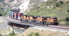
Yes, the CHW is very likely the owner of trackage with farm gates across the track. !*roll-laugh*! It's that kind of railroad; rural and quirky. They run caboose-first for flagmen, engines in the middle of trains, and so on. The old passenger station in Harrisonburg was trying to compete with B&O, so they built it way bigger than the city needed; the CHW's history is full of those kind of oddities. There are 2-3 trains a day, but these days much of the traffic leaves north out of Harrisonburg on NS (SOU) so the lines to Elkton and Staunton don't see as much traffic. Currently, there's also another railroad company - the Buckingham Branch Railroad (http://www.buckinghambranch.com/) - that runs trains out of Staunton to Harrisonburg... running with trackage rights from NS over the CHW (CHW is now a subsidiary of NS). There's still enough industrial traffic in Harrisonburg itself that several trains are running in the city at once, but most of the railway is indeed fairly quiet. There's still occasional interchange traffic between NS and CSX at Elkton, but less often than interchanges at Waynesboro.

Yeah, lots of overgrown rails, weird grade crossings, there's a little station out there that was an antiques shop last time I was out there (years ago), and the station at Stokesville was restored but I don't know what its occupants are doing with it now. I was thinking about going out that way on a railfan/camping trip in a couple months, lots of nice camping in the valley, very pretty place. Been too long since I was out that way.

Initially, I was going to do the route completely unsignaled, but then I found Pike's tutorials and signals, and then I went kind of nuts with signaling after figuring out I could get AI trains to share a main track when signaled. I won't say I've signaled properly, though, that's for sure. !**duh*!! I also want to release the route without any payware, but I got so excited about Pike's signals that I forgot they were payware! *!embar*! Fortunately, I've only signalised part of the route yet, so I'm probably going to do 1) a route without any (or very few) signals and 2) a route with the US default signals. I'm betting this community will pull together honest-to-goodness proper signals for major railroads - we're already on the way I think with stuff like Pike's and SMMDigital's signal work. Also, I agree about the "protofictional" approach, since I have not lived there, just visited. !!*ok*!!

I'm truly honored to hear that my route project is enticing. **!!bow!!** Your C&O Alleghany route is a huge inspiration.

Red
RedWhistle
 
Posts: 65
Joined: Thu Feb 03, 2011 9:55 pm

Re: Crooked & Weedy

Unread postby Toripony » Fri Feb 25, 2011 3:24 am

I think your little railroad had even bigger plans. This is a clip from an 1881 map (I have the hi-res if anyone wants a copy; big .jp2 file) depicting various routes and proposals in the search for The Great Connection -- the shortest route to the Ohio river. Apparently some folks weren't satisfied with the C&O Alleghany route over the mountains because that other proposed route is definitely not shorter! Anyway, this shows what appears to be the CHW running south from Winchester??? Track appears to have been complete to Lexington and portions of some track beyond that, eventually leading to the Hwy 460 corridor near Pearisburg, VA (west of Blacksburg), bypassing Roanoke/Salem completely. There it seems to join what I think is N&W or NS track which could have once been part of The Virginian line. Today that route up to Beckley, WV is NS.

CrookedWeedyAntiqueMap.jpg


That partially complete section goes through a small town I know on U.S. route 311, Newcastle. North of Newcastle, the track appears to follow VA State Rt. 615, a small road I've driven that was obviously once a gentle RR grade. I had always assumed that was maybe a C&O branch at some time. South of Newcastle, the route appears to follow VA State Rt. 42, which is not a gentle grade. That passage is very hilly and curvy with the safest speed on that little road today being about 25 mph. If there is an old RR grade through that 20 miles they should move that road over onto it! lol

CrookedWeedyAntiqueMapClose.jpg


In the closeup of the Harrisonburg area, there doesn't seem to be any sign of the eastward leg of the CHW up to Elkton that early. So THAT'S what that nice little viaduct was, huh?! I always assumed it was part of the original U.S. Rt. 11, but seemed oddly sturdy for that. It's still is good shape but the vines are working on tearing it apart. Btw, unless I am terribly mistaken, Pike's signals are freeware.

!*cheers*!
Tori
You do not have the required permissions to view the files attached to this post.
User avatar
Toripony
 
Posts: 1083
Joined: Thu Jun 04, 2009 3:13 am

Re: Crooked & Weedy

Unread postby RedWhistle » Fri Feb 25, 2011 9:01 pm

Wow, very nice map! !*salute*! Seems my memory is not so good... on several fronts... so, referring to the "Crooked & Weedy" book !!*ok*!! ... in 1881, the route on your map coming down from Winchester is the Valley Rail Road of Virginia, owned by the B&O, that goes through Harrisonburg, Staunton, and reaches Lexington. To the east of that line is the Shenandoah Valley Railroad, financially backed by the Pennsylvania Railroad, which was competing with the B&O to get down the valley. The B&O was headed for Salem and they put in a lot of bridges and grade from Lexington to Salem - the dashed line on your map - but never put down track. In 1881, the Shenandoah Valley Railroad building southward had to decide between going to the competing communities of Salem or Big Lick to meet the N&W in that viscinity. Big Lick won, was renamed Roanoke, N&W moved their headquarters there soon after, and N&W then bought the Shenandoah Valley Railroad... thus the NS line running up the east side of the Shenandoah Valley today.

The CHW started in the 1890's, formed by a junction with the B&O at Harrisonburg, first westward to Bridgewater and Stokesville, then going east to Elkton, and that's when the business about a deepwater coal terminal at Gloucester Point, VA came into the picture. It never got past Elkton to the east, of course, nor past Stokesville to the west, but acted as a small feeder line for the N&W. The CHW purchased the Valley Rail Road section from the B&O between Harrisonburg and Lexington in 1942 - with plans to operate from Harrisonburg to Staunton only, the road between Staunton and Lexington later being abandoned. Still later, all of the CHW that remained - the Harrisonburg to Staunton section and the Harrisonburg to Elkton section, was bought by NS.

Yeah, Pike's signals are freeware... sheesh. *!rolleyes!* I dunno what I was thinking. !**duh*!! In my case, better for people to think I'm an idiot than to open my mouth and remove all doubt. !*roll-laugh*!

Red
RedWhistle
 
Posts: 65
Joined: Thu Feb 03, 2011 9:55 pm

Re: Crooked & Weedy

Unread postby RedWhistle » Fri Feb 25, 2011 9:22 pm

arizonachris wrote:Looking better and better, Red! Whetting my appetite for yet another great route. !!*ok*!!

As far as packing up stuff and giving credit where it's due, if you look at some of the "readme" files for some of the other routes offered here (Tori's route is a great example) you may get an idea of how to give credit and link to additional downloads/ payware that needs to be acquired. Packaging, you're on your own (I'm just a driver, for now anyways !**duh*!! )


Thanks! :D Yah, much to learn from the masters here on route building and packaging. !*salute*!
RedWhistle
 
Posts: 65
Joined: Thu Feb 03, 2011 9:55 pm

Re: Crooked & Weedy

Unread postby Toripony » Wed Mar 23, 2011 9:54 pm

I ran across this little tidbit of information during some research I was doing on the COA today. Apparently they bought or owned this loco in 1941?...............

Chesapeake & Western

109 4-6-0 Baldwin /06 Elkton, Va 9/1/41

source: (http://www.taplines.net/Taplines_Steam_ ... 8_ltr_.htm)
User avatar
Toripony
 
Posts: 1083
Joined: Thu Jun 04, 2009 3:13 am

Re: Crooked & Weedy

Unread postby Kali » Thu Mar 24, 2011 12:52 pm

This is looking like my favourite sort of line ( funny how my favourite sorts of lines are 3000 miles away :p ), just as long as it really is weedy when it's finished! that's one thing I love Bay of Quinte for is the general aura of ... rather less maintenance than there might be.
Kali
 
Posts: 1600
Joined: Mon Mar 14, 2011 1:00 am
Location: England-by-Sea

Re: Crooked & Weedy

Unread postby RedWhistle » Sun May 13, 2012 11:51 am

Wow... I haven't been on in a while. Life has a way of gettin' in the way of things. Hiya everybody. :D Cool find on the locomotive history there, Tori, and thanks for the comment Kali and all. Since I haven't worked on the route in some time, I'm starting afresh and I'll use some of the new features of TS2012 like the asset blocks. Since I bit off more than I could chew with the first time I made the route I'll just model from Harrisonburg to Elkton and then see how that goes. :D
RedWhistle
 
Posts: 65
Joined: Thu Feb 03, 2011 9:55 pm

Previous

Return to Freeware WIP

Who is online

Users browsing this forum: No registered users and 2 guests