Whats more is that all the seasonal default TOD files have their azimuth angle all set to the same parameter of -1.0000. This not only puts the position of the sun in the wrong part of the sky for North America, it also means the sun is in the same position every season.

I was experimenting last night and made a set of TimeOfDay files that more accurately depict the position of the sun in the sky in North America for each season.
I blueprinted a custom set using the parameters from the Horseshoe Curve route since It has the best color pallet. I then adjusted the azimuth angle to position the sun in the sky according to where my route is located in the northern hemisphere. I'm pleased with results so far.
Let me show you what I mean:
A screenshot of the route using the the default TOD files. High noon in Summer and the camera is facing due east. However, as you can see by the shadows on the ground, the sun is off to the right when it should be almost over your head and off to the left.

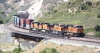
Now a screenshot with the azimuth angle properly adjusted. High noon, in Summer facing due east. As you can see, the position of the sun is just about where it should be. Almost over your head and off to the left.

Comments welcome. After a little more tweaking, I'll offer them to anyone who wants to use them in your route projects.


 Well, actually, their shadows are wrong too then cause the Sun never shines straight down on England either.